Severe Weather Chances Picking Up
It’s been a very slow beginning of 2025 in terms of severe weather that we can work with. Yes, there’s been a few higher risk days and some tornado outbreaks, but this hasn’t been the typical late winter / early spring. Looking back at past seasons, some as far back as around 2015, there’s usually ample opportunities to get out and live stream severe weather somewhere in the south or along the Gulf Coast. For example, last year there were multiple days as early as January where several rounds of severe storms occurred along I-10 in Mississippi, Alabama, and Florida. This year, not so much. That looks to change soon.
Thursday
A pretty basic severe weather risk, mostly for hail. We’re not really expecting tornadoes or big wind-producing squall lines, but individual supercells should have strong enough updrafts to produce large hail.

SPC: Thursday
The focus looks to be the Omaha region. This is a pretty large level 2/5 risk, but the best chances for robust day-time storms likely will focus on eastern Nebraska and western Iowa. Taking a look below, at the HRRR model around 7PM tomorrow, there’s a cluster of storms expected to be on-going in northern Iowa and southern Minnesota. The main show will be those likely-to-develop storms you can see in Nebraska near Lincoln and Grand Island. They should form in the 3:30PM to 6PM central time frame, then move off to the east as they develop. It’s possible the initial target may end up being west of Omaha by the afternoon.

HRRR future radar composite for Thursday at 7PM. -RadarOmega
Friday
Looks like on Friday the target could move east or south. Illinois could be a focal point, but some data has suggested heading toward Oklahoma. Either way, it’s a generally low severe risk day and details will need to be ironed out.

SPC: Friday
I'll post the rest of the week’s SPC forecasts below, but don’t have much of a plan for these days…yet.
Saturday
SPC Saturday
Sunday

SPC Sunday
Looking farther ahead…
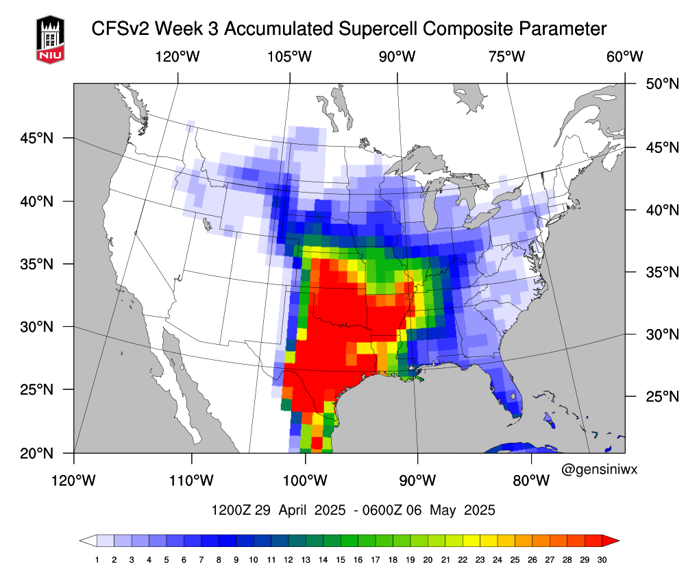
One model-based tool we can use is the CFS Accumulated Supercell Composite Parameter map. This basically plots a heat map where models indicate the best risk for robust storms are. It’s by no means a high-resolution or decision-making tool, but it gives a good overview of what may be ahead.
Next Week
According to the model, we will likely see severe weather return to much of Texas and Oklahoma, which is to be expected for this time of year.

The Following Week
Storm risk expands to include much of Kansas and even into the middle Mississippi Valley region.