
June 16: Nebraska Deployment

Minnesota - Today
This morning, thunderstorms are already rolling through parts of Minnesota, which makes it a bit hard to pin down exactly how things will play out later today. The air is pretty humid, with dewpoints in the low to mid-60s in southern Minnesota, and that moisture is expected to creep northward into central and northern parts of the state by this afternoon. With some filtered sunlight heating things up, we’re looking at enough instability for storms to fire up, probably between 3-5 PM.
The biggest concern is in central and northern Minnesota, where the setup looks favorable for severe thunderstorms. Storms could start as supercells, thanks to strong wind shear. That means we could see scattered large hail, possibly even some stones over 2 inches in diameter. There’s also enough low-level shear near the low-pressure system center to raise the risk of a few tornadoes, especially along a warm front stretching west to east across central and northern Minnesota. By early evening, these storms might merge into clusters, bringing a higher chance of damaging winds into eastern Minnesota and western Wisconsin. Things should start to calm down tonight as the storms move into less favorable air to the east.
There’s still some uncertainty about how far south the worst storms will hit in Minnesota or eastern South Dakota, so stay sharp if you’re in those areas.

Northern and Central Plains - Today
Out in the Northern and Central Plains, we’ve got another active weather day shaping up. In southern Montana and northern/eastern Wyoming, expect storms to start popping up near the higher terrain by mid to late afternoon. A subtle upper-level disturbance and strong wind shear will help fuel these storms, which could turn into isolated supercells. These storms might produce large to very large hail as they move east-southeast across the northern High Plains. If they cluster up this evening, we could also see some severe wind gusts, especially with the hot and well-mixed air in place.
Meanwhile, in Nebraska and parts of eastern Wyoming and northern Colorado, more robust thunderstorms are likely to form along a front stretching northeast to southwest. The air here is primed for strong to extreme instability, thanks to intense daytime heating and a moist atmosphere. We’re talking a mix of supercells and storm clusters, with large hail and damaging winds as the main threats. In western and central Nebraska, there’s even a chance for isolated wind gusts over 75 mph if storm clusters really get organized.
Today’s Target: Nebraska.

Kansas - Tomorrow
As temperatures climb during the day, storms are expected to kick off, likely by early afternoon, a bit farther to the northwest in the slightly higher terrain. These storms will push into the lower elevations through the afternoon, where the air is set to become moderately unstable. The HRRR model is showing a pretty aggressive setup, suggesting a line of organized storms could form and move southeast across the Central High Plains by Tuesday evening.
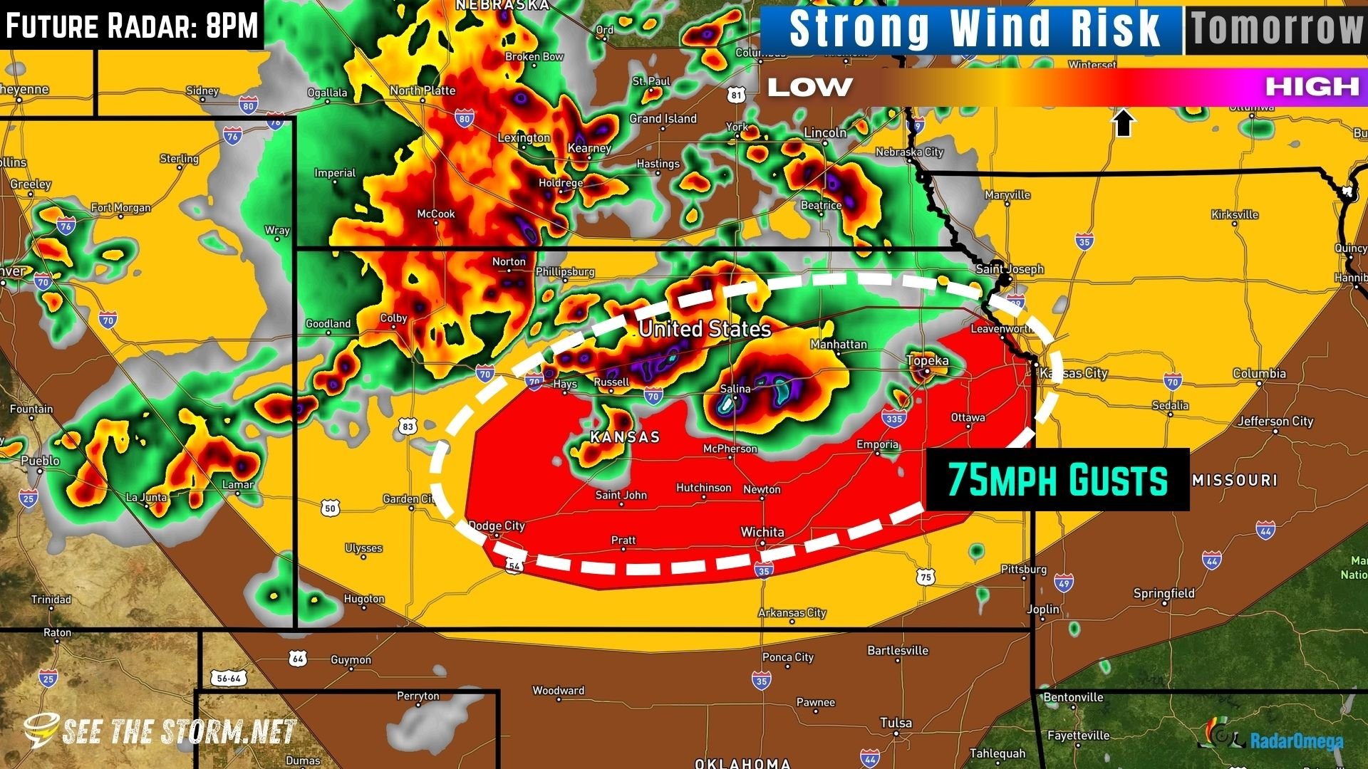
The atmosphere looks primed for severe weather, with forecast soundings showing 0-6 km wind shear between 30 and 40 knots and steep lapse rates of 8 to 9 °C/km in the mid-levels. That kind of environment can support some intense storms. The main threats will be large hail and damaging wind gusts, especially with the stronger parts of the storm line.
Here’s the photos from the last few days:


