
May 4: New Mexico & Texas…again
A dynamic weather pattern is setting up across New Mexico and West Texas over the next few days, bringing severe storms!
Today

Today, warm and humid conditions will fuel scattered thunderstorms across northern and east-central New Mexico, with a few storms possible in far southeast New Mexico and west Texas. A level 2 of 5 (slight) risk for severe storms is in place for areas like Roswell, Carlsbad, Hobbs. The atmosphere is primed for strong storms, especially in the late afternoon. Some of these could become well organized, producing large hail and strong wind gusts. There’s also a small chance of a tornado, although it’s pretty low. Big hail is the main risk.

The forecast dew point (moisture) map from RadarOmega and the HRRR model illustrate the humid conditions. Those bright green colors indicate 55F-60F dew points, which is pretty high for this semi-desert area. That should be more than enough for storms.

The supercell composite values are highest in the southeast corner of New Mexico, which is where we expect the greatest risk of very large hail and maybe a tornado (maybe). This composite map basically just gives us values on the map to indicate that there’s plenty of severe weather ingredients in place. A ‘supercell composite’ is not a physical thing in the atmosphere, rather a computer model value.

It looks like the future reflectivity product backs this up, too. Here’s how storms may evolve around 7PM this evening.

Project WeatherEye is focusing in on the red circled area, but may expand into the orange if needed. However, given the simple fact that there is very little Verizon and ATT coverage in rural areas out here, it may not be possible to deploy streaming equipment. This will be a case-by-case basis.
Tomorrow
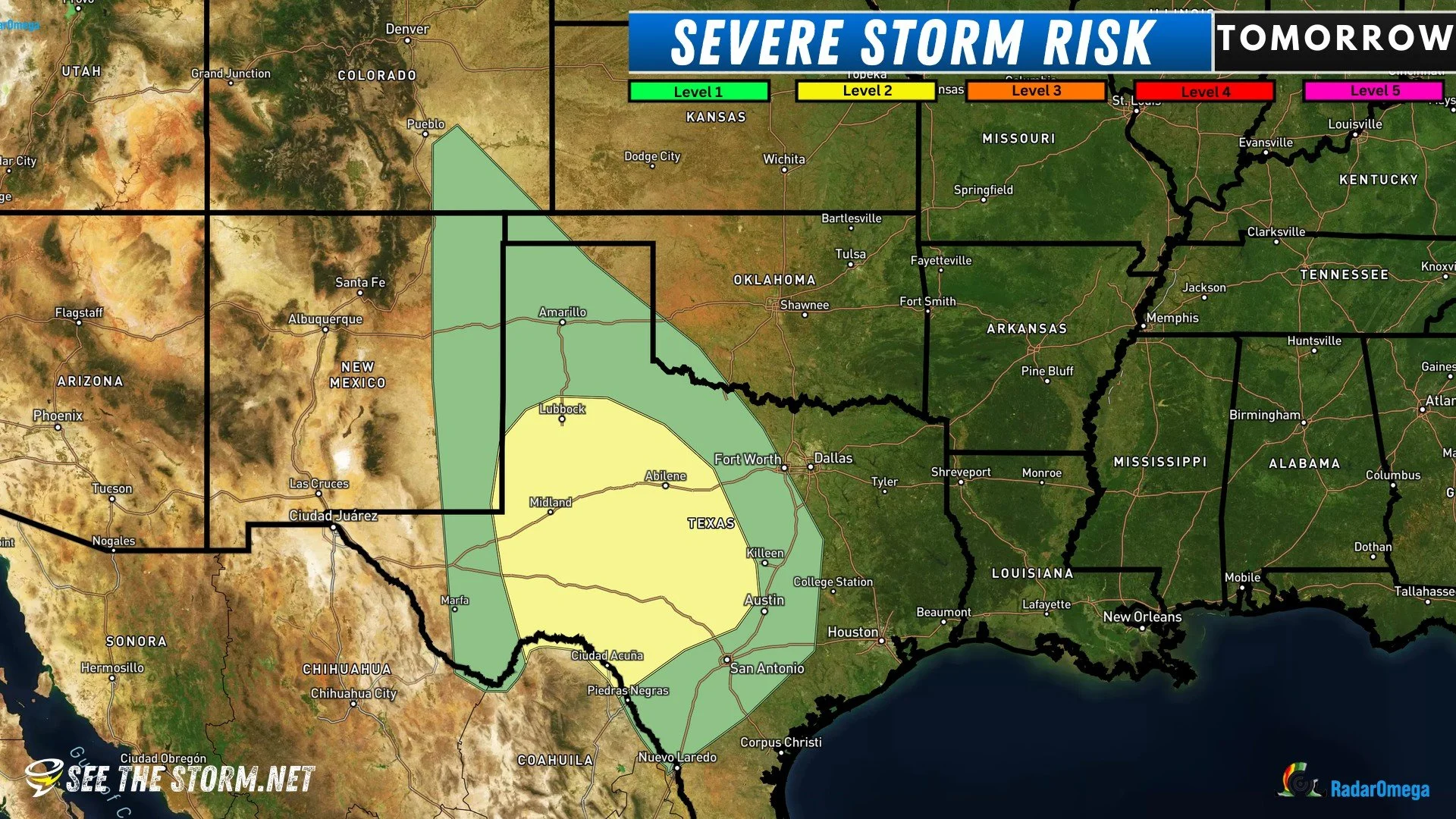
There’s a large level 2 of 5 (slight) risk for much of west and central Texas on Monday. By afternoon, heating along a boundary in far eastern New Mexico and West Texas will spark thunderstorms. These storms could be severe, with the potential for very large hail and damaging winds. In the early evening, conditions may become more favorable for tornadoes, especially in the brown circled area below— Midland, Odessa, Big Spring, and up to Lubbock.

Tuesday

Tuesday’s forecast is less certain due to expected early morning rain and clouds. However, warm and humid conditions are likely to set up south of a warm front. This could lead to strong thunderstorms in the afternoon. Some storms may produce very large hail, strong winds, and possibly tornadoes. While the potential for significant severe weather exists, it’s too early to pinpoint exact locations due to differences in weather models, and the SPC backs this up.